Daftar isi
In most oil palm plantations, cellular internet is practically absent. It only becomes available once a truck reaches the mill. As a result, the head office does not know where the trucks hauling fresh fruit bunches (FFB) are, and foremen can only ask by handheld radio. This article summarizes a paper that tackles the problem with inexpensive hardware: a GPS module, LoRa radio, and the mill’s WiFi.
Arifianto, M. J. F., Muhim, D. M., & Rosyidi, E. (2020). Rancang bangun sistem pemantauan lokasi berbasis GPS, LoRa dan WiFi pada kendaraan angkut perkebunan [Design and development of a GPS, LoRa, and WiFi location monitoring system for plantation transport vehicles]. Proceedings of SNEEMO (Seminar Nasional Efisiensi Energi untuk Peningkatan Daya Saing Industri Manufaktur & Otomotif Nasional), Jakarta, 25 September 2020, pp. 63–69. Paper code CB-07. The paper is written in Indonesian.
The problem in the field
FFB must reach the crude palm oil (CPO) mill on time to preserve fruit quality. The head office schedules trucks from the previous day’s harvest analysis and passes the plan to the transport foreman. In plantations outside Java, this is hard:
- No cellular internet inside the plantation, and limited road infrastructure.
- Truck queues at the collection point cannot be predicted, so waiting times are long and disrupt production.
- Truck positions are not tracked, because foremen and drivers communicate only by handheld radio.
- Frequently used routes are unknown to the infrastructure team, so road repairs, especially in the rain, are often poorly targeted.
The authors identify three gaps: no tool to monitor trucks about to enter the mill area, no tool to locate a truck when the driver is in an abnormal situation, and no tool to learn which roads drivers tend to choose.
What came before
The paper mentions two other approaches. GPS and geospatial tracking of CPO trucks by Pasaribu (2020) is processed afterwards (post-processing), so locations cannot be seen in real time. A mobile app using GPS and GPRS/WiFi by Abdullah et al. (2015) depends on an internet connection. Neither suits a plantation without coverage.
The authors chose LoRa for its long range (about 5 km under fairly optimal conditions) and low running cost. The paper refers to the 920–923 MHz band, which is licence-exempt in Indonesia under 2019 Kominfo and Ditjen SDPPI regulations.
Core idea: three areas, two modes
The system is designed around radio coverage. GPS is received in all areas.
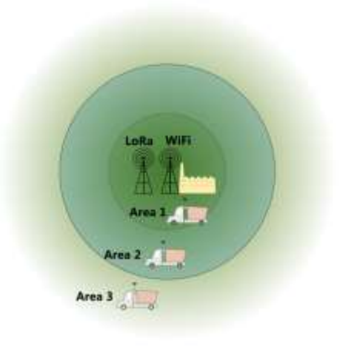
| Area | Coverage | System mode |
|---|---|---|
| Area 1 | LoRa and mill WiFi, radius about 200 m | Route file uploaded to the server over WiFi |
| Area 2 | LoRa only, radius about 5 km | Online mode: position sent live over LoRa |
| Area 3 | Neither LoRa nor WiFi | Offline mode: position stored on the device |
With this split, trucks are always tracked. Deep inside the plantation, the route is recorded. Near the mill, the live position appears. Once the truck arrives, its full route is uploaded.
System requirements set by the authors:
- In Area 3, the device saves location data automatically every 5 minutes and deletes files about 4 days old or more.
- In Area 2, the device sends location over LoRa at an interval adjustable down to every 5 seconds.
- In Area 1, the device sends the GPS data file to a PC server over WiFi.
- Routes and locations are displayed on a map.
Hardware
There are two devices. The LoRa Node is mounted on each truck, and the LoRa Gateway is fixed at the mill.
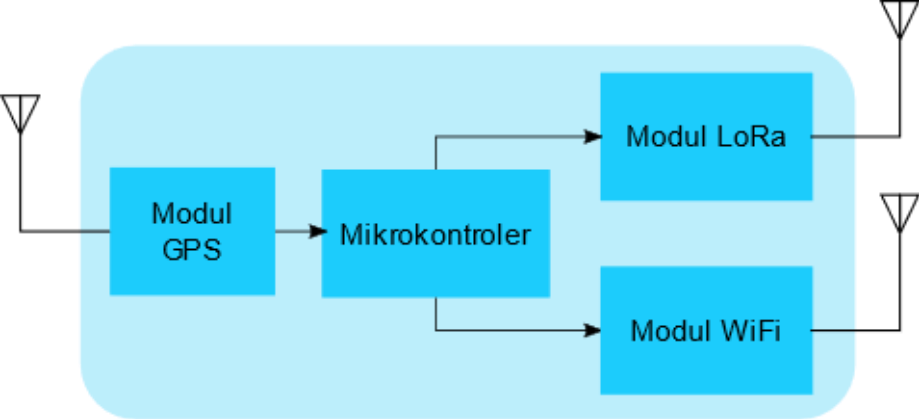
| Component | LoRa Node (truck) | LoRa Gateway (mill) |
|---|---|---|
| Board | TTGO T-Beam | RFM95 LoRa module and ESP8266 |
| Microcontroller | ESP32 (with WiFi) | ESP8266 |
| GPS | NEO-6M (serial interface) | None |
| LoRa | SPI interface | SPI interface |
| Transmit power | 0.1 W | 0.1 W |
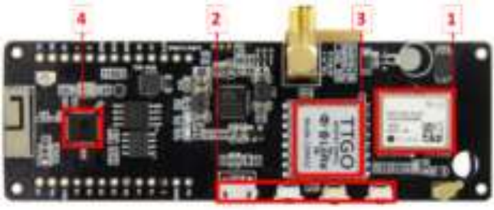
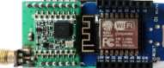
The gateway is a single-channel type, meaning it listens on one frequency only. The LoRa Node runs from a 5 V battery (a phone power bank), and the modules sit in a protective enclosure with the antenna outside.
Software
- Arduino IDE to program the ESP32 and ESP8266, chosen for its many libraries and large community.
- The Things Network (TTN) as the server that receives gateway packets in online mode. TTN Mapper shows the location.
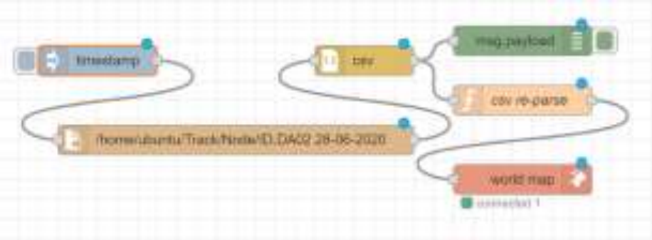
- Node-RED to display routes from GPS text files on a map using the world map node in a web browser.
How the two modes work
Offline mode (Area 3)
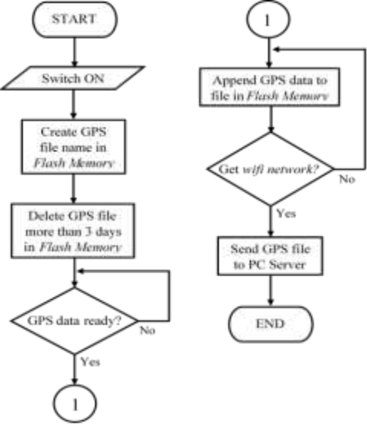
The program runs when the switch is on. The device creates a file named after the vehicle ID and the operating date, deletes old files from flash memory, then appends GPS data each time a fix is available. Each row holds truck identity, date and time, latitude, longitude, number of satellites, and altitude. The 5-minute interval was chosen because harvesting takes long, so data does not grow too large. When the device finds the mill’s WiFi, the file is sent to the server through a PHP application.
Online mode (Area 2)
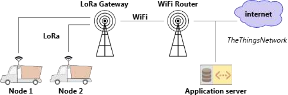
The device reads GPS and builds a data packet that is deliberately small for speed and accuracy, then sends it when it detects the gateway. The gateway forwards the packet to the application server through TTN. If no signal is found, the device goes back to reading GPS.
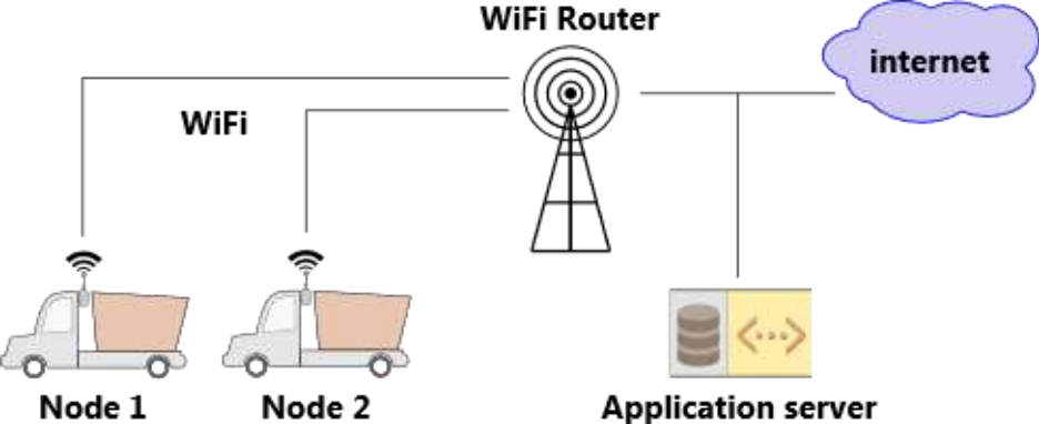
When the truck returns to the mill, the route file is sent over WiFi.
Test results
Offline mode. The device was carried around to simulate harvesting. The LoRa Node was able to:
- create file names from vehicle ID and date,
- delete files 4 days old or more,
- save location data automatically to microcontroller memory,
- read location data, and
- send the GPS route file to the server over WiFi.
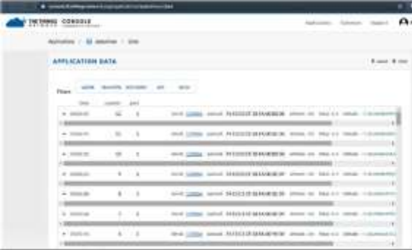
Online mode. The gateway was placed at a fixed position and the node was mounted on a moving vehicle. The node read its location and sent it as packets, which were received in the TTN console.
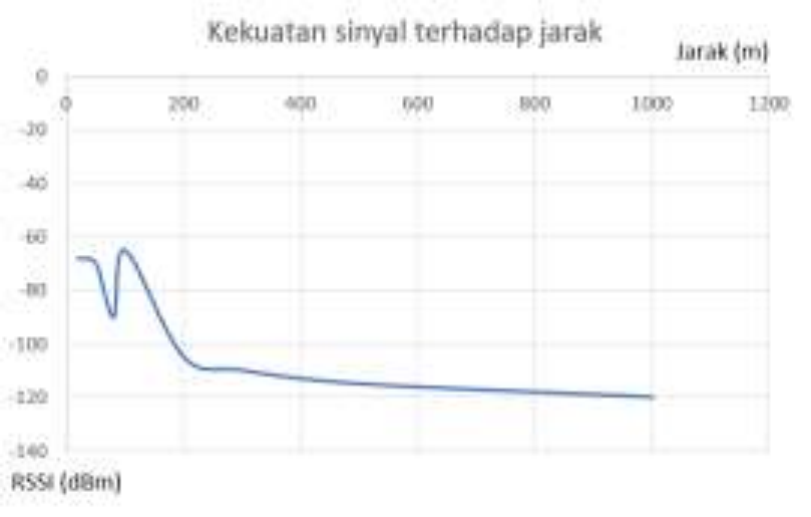
Distance and signal strength. The paper also measured RSSI against distance. The gateway was indoors, the node was moving, distance was measured with a map app, and both modules transmitted at 0.1 W. According to the paper’s graph (the following figures are read from the graph, not from a data table), RSSI is about −68 dBm near the gateway. It drops quickly over roughly the first 250 m, then flattens out to about −120 dBm at around 1 km.
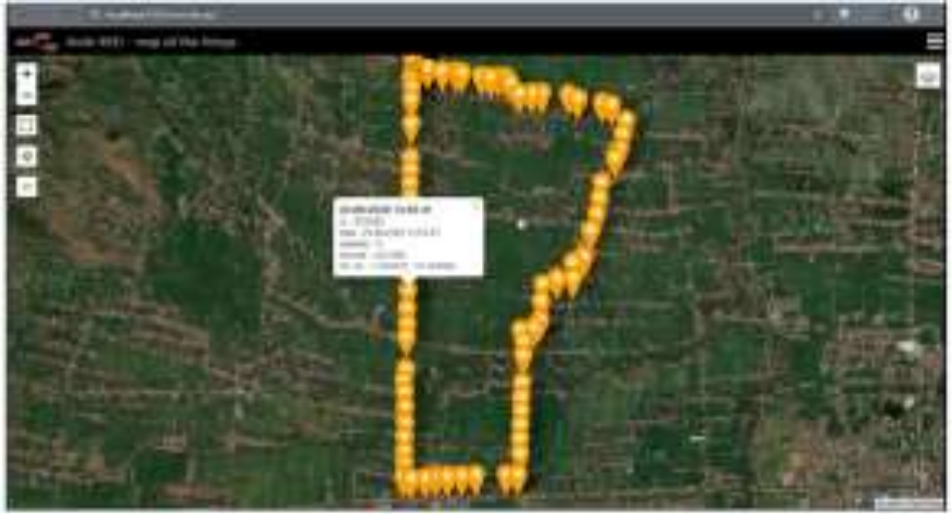
Route display. The GPS files from the offline test were loaded into Node-RED and appeared as a trail of points over satellite imagery. In online mode, locations are viewed through TTN Mapper.
The authors’ conclusions
- A location monitoring system for harvest transport vehicles can be realized with offline and online LoRa modes, using an ESP32 microcontroller on the TTGO T-Beam board.
- The offline program can track and record truck routes. Data is kept in microcontroller storage for 4 days before being sent to the server.
The authors suggest that LoRa range could be extended by optimizing antenna placement.
How to read these results
- The tests are functional: they show that each function works. The paper does not report the effect on truck waiting times or queues in a real plantation, which was the original motivation.
- The distance data was taken with an indoor gateway up to about 1 km. The 5 km range comes from the optimal conditions cited in the literature review, not from a measurement in the paper.
- Online mode relies on a single-channel gateway. Because it listens on only one frequency, capacity for many trucks needs further testing.
Why it matters
This system shows that useful tracking does not always need a cellular network or a subscription service. With low-cost hardware and a licence-exempt frequency band, a plantation company can get two things at once: near-live positions of trucks approaching the mill, and recorded routes that help schedule trucks and decide which road sections need repair.
Selected references
- Abdullah, Muhadi, A., & Atirah, N. (2015). GIS data collection for oil palm (DaCOP) mobile application for smart phone.
- Astra Agro Lestari. (2020). Digitalisasi di industri sawit sebagai solusi new normal. https://www.astraagro.co.id/2020/06/03/digitalisasi-di-industri-sawitsebagai-solusi-new-normal/
- Pasaribu, A. (2020). The use of geospatial technology to monitor the transportation of crude palm oil trucks.